Satellite data and AI: master formula to tackle the legislative welter of ESG vectors – okdiario
The renowned physicist Albert Allen Bartlett began his lectures with an axiom that could well be the mantra of the 21st century: “The greatest deficiency of the human race is our inability to understand the exponential function”.
His warning is prescient in a world that demands abandoning linear thinking and embracing exponential thinking. Artificial intelligence (AI) brings us closer to this paradigm shift. A technology that went from being incipient to having the capacity to pass a university course autonomously.
CSRD, ESRS, EUDR… The control and bureaucratization of natural resource management and human survival itself have generated an endless number of empty terms, anglicisms and acronyms that, far from connecting with social reality, amplify its disconnection.
Geospatial data and AI
Since the popularization of the term “sustainable development” in the 1980s, the concept has suffered a progressive loss of meaning and purpose.
In this context, geospatial data science and artificial intelligence (AI) become a master formula to facilitate the regenerative economy.
Innovate to achieve the regeneration of natural resources, thus facilitating human survival. The time has come to reverse what Nature Magazine announced in 2020: man-made objects have, for the first time, exceeded the weight of biomass.
Key tool
Planetary sustainability seemed far away and suddenly became a priority to ensure the future of our societies. Isn’t exponential thinking something we have experienced in our own flesh?
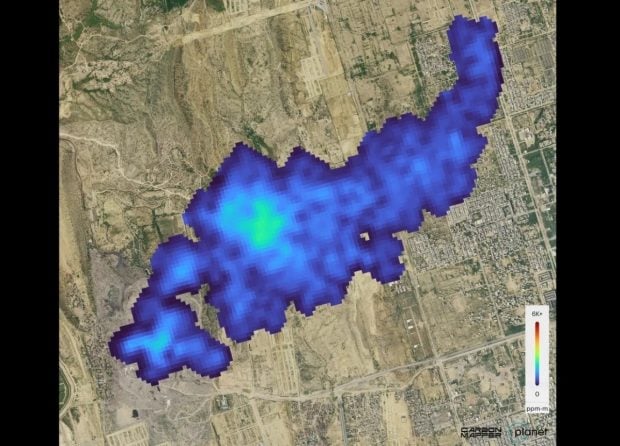
Territorial intelligence emerges as the key tool in this transition. Each year, more than 2,500 satellites are launched into orbit with sensors that capture accurate information about human impact on the planet.
These data, processed through AI, make it possible to “put the map at the service of the territory”. An innovative perspective offers companies and public administrations a compass to navigate the complex ESG vectors (environmental, social and governance) without losing sight of the need for economic growth.
Predicting water leaks
Water stress is a striking example of this global crisis. By 2050, nearly 50% of the world’s population is expected to experience this directly. Spain, for its part, loses more than 650 billion liters of water a year before it reaches the tap.
It is not a question of scarcity, but of focus. Geospatial data and AI make it possible to predict more than 80% of water leaks and reduce losses by up to 55%. This is equivalent to savings capable of supplying the whole of Europe for a year.
The problem of sustainability does not lie in the lack of information, but in its interpretation. The information provided by satellites and predictive or analytical AI models act as the alchemist of the 21st century. Transforming data into knowledge and knowledge into decisions. The applications are endless, not everything lies in water.
It’s not science fiction, it’s reality
Identify materials that constitute a public health problem such as asbestos with an accuracy of more than 90%; identify flood-prone areas and homes that could be affected by these phenomena and implement strategies to avoid them; help large and small farmers to increase the productivity of their crops; develop tools to monitor biodiversity and estimate the capacity to capture CO₂ at a global level or, even, extract standardized indexes on water pollution or the degree to which vegetation is affected after a fire in a simple way and with unprecedented accuracy.
It’s not science fiction, it’s reality. Faced with the rise of denialism on such important issues as climate change or deforestation, satellite data and AI help to represent the problems on a map.
Fuzzy concepts that acquire form and dimension. This is something that companies will undoubtedly have to start incorporating into their non-financial reporting.

Strategic decisions
Satellites and AI to obtain accurate data to nurture the self-awareness of companies and governments about their impact on the operating environment to make strategic decisions that benefit their bottom line and the livability of cities.
Sustainability requires abandoning the binarism that pits economy and ecology against each other. Both vectors are interconnected. AI and geospatial data are catalysts for this convergence, enabling strategies that balance environmental impact with business profitability.
Transformative sustainability
In a world where the term sustainability seems to have lost its original meaning, these technologies bring a new narrative, based on tangible facts and possibilities.
Far from being an exhausted concept, sustainability finds in these tools an opportunity to renew itself and recover its transforming essence.
Time is pressing. Climate catastrophes and resource scarcity are no longer hypothetical scenarios, but palpable realities that demand immediate responses.
Hopeful future
The combination of geospatial data and artificial intelligence is not a luxury, but an unavoidable necessity. In their ability to process complex information and generate applicable solutions lies the hope for a future where sustainability is no longer an abstract ideal but an effective, everyday practice.
The era of data has arrived. The time to make decisions with real impact. It is not about talking about concepts such as dual materiality. The issue lies in measuring how activities impact the operating environment and vice versa. To take on board the planetary reality and make decisions – often simple ones – to reverse the situation.
Guillermo de Santiago ES Head of Growth at Agforest
See complete article here.
