Guide to removing asbestos: keys to eradicating asbestos in municipalities
To date, the Fourteenth Additional Provision of Law 07/2022, of April 8, on waste and contaminated soil for a circular economy did not have adequate regulatory development. This lack of regulation has been one of the main reasons why many municipalities have experienced delays in preparing the census of facilities and sites with asbestos.
However, in June 2024, the Directorate General of Public Health published the “Guidelines for the removal of installed asbestos. Preparation of a census of installations and sites with asbestos and prioritisation criteria for their removal. Management of waste with asbestos” . Although this document is not binding, it constitutes the first official guide that offers municipalities a framework for addressing asbestos removal.
In this context, the experts at Agforest, a leading company in asbestos remote sensing in Spain , have developed a guide for asbestos removal based on these guidelines, highlighting how geospatial artificial intelligence (GeoAI) can transform the way in which municipalities manage the asbestos removal process. Whether you work in public administration or are a citizen concerned about public health, this information will be very useful to you. Keep reading!
What is asbestos removal?
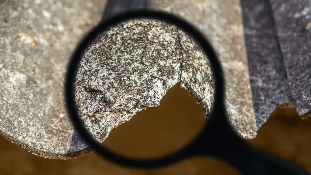
Asbestos removal refers to the complete process of identifying, removing and safely managing fibre cement containing asbestos. Despite the ban on the use of this material in Spain since 2002, many infrastructures, especially roofs and pipelines, still contain it. The danger of MCA (Materials Containing Asbestos) lies in the release of dangerous fibres when the material deteriorates, which typically occurs at the end of its useful life, between 20 and 30 years.
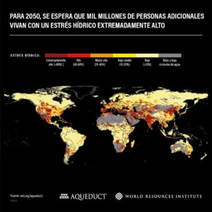
The European Commission , through its Asbestos-Free-Future strategy , urges member state governments to take immediate action to accelerate asbestos removal, with an ambitious goal: to eradicate this material by 2032. In this context, GeoAI emerges as an innovative solution. Thanks to its ability to identify asbestos in roofs with an accuracy of up to 90%, as demonstrated by the algorithm developed by Agforest, this technology can speed up all phases of the asbestos removal process.
GeoAI in critical phases for asbestos management
Due to its dangerous nature, the inspection and removal of asbestos is a delicate process that requires a high degree of specialization. Based on the guide of the General Directorate of Public Health and Health Equity, municipalities must follow the following steps to comply with Law 07/2022, of April 8:
Exploration, basic census and detailed inspection
Determining the amount of asbestos present in the real estate stock of municipalities is key to the subsequent management of its removal. While it is true that statistics can help to know the degree of susceptibility of different facilities and sites to containing asbestos, this is insufficient to comply with Law 07/2022, of April 8. The General Directorate of Public Health and Health Equity collects remote sensing, based on GeoAI, for the correct identification of fibrocement roofs with asbestos and their link with cadastral data , offering a real overview of the asbestos situation in the municipality.
The result of remote sensing is what the regulations call a “basic census”, a first approximation to the inventory of asbestos in the municipality. The results of this study are crucial for subsequent detailed inspections of critical facilities. Complement remote sensing with field work in those critical infrastructures referred to in Law 07/2022. These inspections, sampling and laboratory analysis must be carried out and managed by certified technicians based on the UNE 171370-2 Standard.
Risk assessment and withdrawal schedule
Asbestos is not only found in the roofs of buildings, but also in other places such as the sewage and water supply network. Likewise, not all facilities and sites with asbestos are located in areas with the same level of risk for citizens. The Fourteenth Additional Provision of Law 07/2022, of April 8, includes the need to act on public and high-risk sites before 2028.
To do this, a calendar or plan for the removal of asbestos in the municipality must be carried out based on the UNE 171370-2 standard. GeoAI makes it possible to take into account all the facilities and locations of the building stock, as well as the sewage and water supply network. In this way, those responsible for the public administration will be able to have detailed information for making strategic decisions in relation to asbestos removal.
AI analytical models applied to cartographic visualisations allow the assessment of the real risks of exposure to asbestos for citizens. Thus, not only the basic variables of the UNE 171370-2 Standard will be taken into consideration, but also the proximity to critical sites such as schools, hospitals or health centres, among other factors, will be analysed.
Removal of asbestos and disposal in authorized landfills
Once this analysis and planning process has been completed, the removal of asbestos must be carried out by a specialised company that follows the necessary safety measures and is registered in the Register of Companies with Asbestos Risk (RERA). It is important to emphasise that current regulations do not allow the same company to carry out the inspection and removal of asbestos to ensure the correct management of this material.
The process must take into account critical aspects such as isolating the area where the removal will take place; the use of personal protective equipment (PPE) by the team involved, or avoiding the breakage of the MCA (material containing asbestos) to prevent the dispersion of the fibres of the material. Once the material has been removed, it must be safely transported for disposal in authorised landfills.
GeoAI, support in the asbestos removal process
Using GeoAI in the asbestos removal process offers numerous benefits, especially for municipalities that must manage multiple areas with asbestos presence. These include:
- Greater detection accuracy: identify structures with asbestos more quickly and accurately than traditional methods.
- Resource optimization: By prioritizing the areas of greatest risk, municipalities can save resources and time, reducing the number of physical inspections required.
- Report Automation: Generate automated reports that document identification, risk assessment and recall planning, facilitating compliance with legal requirements.
- Real-time monitoring: continuous monitoring of the status of asbestos-containing structures and the waste generated, improving transparency and control throughout the process.
Sources consulted:
- https://www.boe.es/eli/es/l/2022/04/08/7/con
- https://www.insst.es/documents/94886/5326464/DIRECTRICES+DA+Ley+Residuos+JUNIO+2024.pdf/52100f72-6f32-a1d0-e4d1-142fae797a0e?t=1720086345197
- https://agforest.ai/censo-de-amianto/
- https://ec.europa.eu/social/main.jsp?langId=es&catId=89&newsId=10418&furtherNews=yes